
FltPlan Go for iPhone
How much does FltPlan Go for iPhone cost?
Prices are current as of 9 Sept 2026.
FltPlan Go for iPhone has no in-app products on record in the United States.
10+ alternatives to FltPlan Go for iPhone
| FltPlan Go for iPhone |   SkyDemon SkyDemon |   Air Navigation Pro Air Navigation Pro |   Navigraph Charts Navigraph Charts |   Sporty's E6B Flight Computer Sporty's E6B Flight Computer |   Airmate Airmate |   LiveATC Air Radio LiveATC Air Radio |   FlyQ+ EFB FlyQ+ EFB | 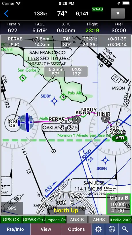  WingX® WingX® |   ATC Air Traffic Control ATC Air Traffic Control |   Air Traffic Control Live Air Traffic Control Live | |
|---|---|---|---|---|---|---|---|---|---|---|---|
| Rating / 5 | 4.1 | 4.9 | 4.6 | 4.9 | 4.9 | 4.6 | 3.4 | 4.1 | 3.4 | 3.6 | 1.5 |
| Reviews | 192 | 34K | 20K | 9.9K | 6.4K | 4.9K | 1.8K | 929 | 213 | 190 | 79 |
| Released | 2014 | 2012 | 2009 | 2015 | 2010 | 2016 | 2009 | 2014 | 2010 | 2023 | 2023 |
| Annual price | — | — | $79.99 | — | — | $24.99 | — | — | — | — | — |
| One-time price | — | $199.99 | $9.99 | — | — | $8.99 | — | — | $0.99 | — | — |
The going rate for each plan in United States, in its own currency, shaded from the cheapest price on the row to the dearest.
FltPlan Go for iPhone reviews
4.1 out of 5, based on 192 reviews.
What people like
- Totally free to use with no ads
- Works with many different ADS-B devices
- Connects easily to flight simulators
- Charts update quickly with just one click
What they complain about
- Keeps crashing when you open it
- Login details disappear every time you restart
- Interface feels slow and lags constantly
- Download errors happen way too often
Flight plan go
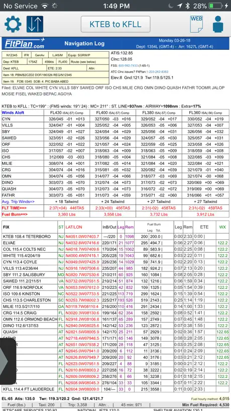
Works great with most ADSB units. Best of all it’s free. Has about every function you might need. Not quite as intuitional as I would like but reading the manual fixes that. It is my go-to app when in the airplane.
Bye Bye FREE
Since Garmin got their greedy hands on this once wonderful, free app, it's only a matter of time before they eother shut it down or start charging an arm & leg for it. Typical business practice for Garmin. Ex. in order to force their loyal customers to buy their new GTNs, they stop supporting the 430/530s. Criminal imo.
It’s nice
I love it. I can connect it to my simulator! Only issue is, I wish it can connect to the newest simulator which is MSFS 2020. :) I wish
App started to crash after recent update
App started to crash after recent update
Not the best option
Not the best option for me and connecting to Stratux. Offline maps aren’t helpful absurdly limited, it makes no sense.
First App I Tried Since Two Decades Ago.
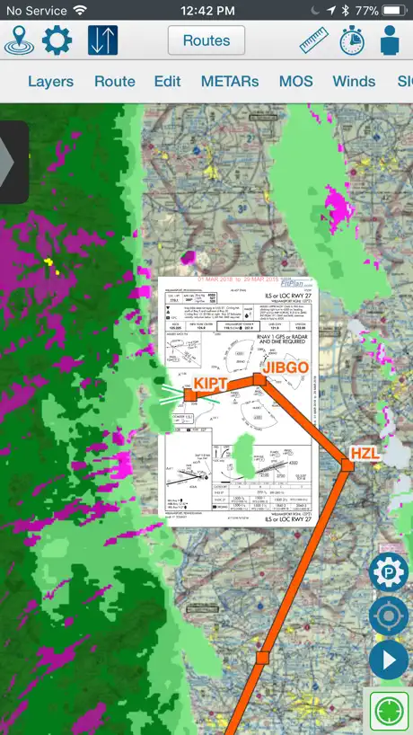
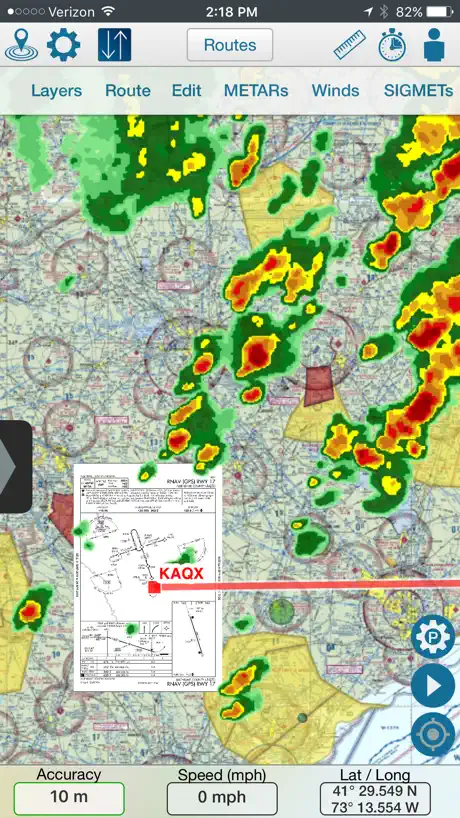
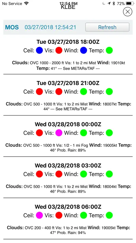
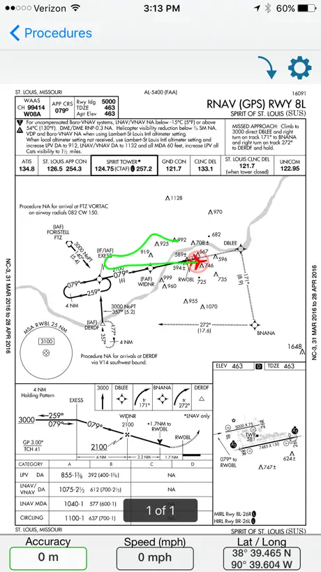
Came back to flying since from the mid ‘90s. Back then I needed two Jeppesen binders to cover the NE region and updating was a pain in the.....With this baby, I keep VFR, IFR and A/FD for my current area in the size of an iphone 7; and update with a click of a button. Just this ability is already amazing, now add the GPS, moving maps, superposition of weather, SIGMETs, METARs and approach plates onto the map, just WOW! I don’t need to compare it to paid services. UPDATE 02/23/21 Still WOW! Still using this baby, still don’t need to compare to paid EFGs. I use it to file and fly IFR. I found an old iPhone6 Plus (perfect size for my tight Mooney), and runs in iOS 12 w/o issues; this app is not hungry for OS updates, I like that. I just hope it stays free for the rest of my flying life; even if I have to donate a bit.
Doesn’t work
I downloaded the app, opened it and was immediately hit with a “failed to download database” error. Tapping retry does nothing.
Cfs pages
This app is very useful for the flying I do, the only thing that I notice is that in the cfs pages, some airports are missing pages that include waypoints or other important information. One of the airports that are missing this page is Red Deer regional (cyqf). Other than that this app is useful and great for flying
you will get spammed
If you enter your phone number into this program when It asks for information to sign up and login, they will put you on a spam list so if you want to get tons of sales calls, have at it. 👎🏻
Saftey
Update: thank you for fixing. But after the extended time, i bought non garmin offerings. ——- Abandoned app Broken safety features that makes it dangerous for pilots No updates in over 10 months Don’t install
No Stratux under iOS14
A great aviation app and many thanks to FlightPlan for the recent update to let it work with Stratux (couldn’t connect to Stratux in iOS14 before the recent update). Works great!!
Update
This app has very high potential if they only update the interface to make it more mobile friendly, it is a replica of the website. This brings a lot of problems to the app. Such as big files to download and slow speed in the app. Please consider a user friendly app such as foreflight or garmin. Stay ahead with the synthetic vision and profile view.
Amazing features and FREE
I have used Garmin Pilot, ForeFlight, FlyQ, all which are excellent, but so is FltPlan Go. It has all the features that the basic subscriptions to the others have, all of which charge more for the eye candy, such as synthetic vision and AHRS (although it does have an instrument panel feature). FltPlan even has geo-referenced charts, approach plates and taxi diagrams that others charge extra for. Works with the widest range of ADS-B in devices, unlike ForeFlight which only works with Stratus and Stratux, and Garmin Pilot which prefers Garmin devices. FlyQ also works with a large variety of devices. The menu structure takes some getting used to, but that’s true for every app. Not as pretty or slick as the other premium apps, but has everything you need to navigate safely. And FREE, but recently purchased by Garmin, so who knows how long the product will remain free. A must-have app with good product support. I have it on all my devices, mostly as a backup, but I try to use it occasionally so I don’t forget how things work. My favorite EFB is ForeFlight, but that is Apple iOS only with only Stratus and Stratux (excellent).
Needs improvement
I use the website more than the app... sometimes the loading icon doesn’t go away. Needs to be optimized for iPhone X.
Crashes a lot on iPad Pro 11” 1st Gen
For the free price, this is a useful alternative to ForeFlight. I like connecting it to Microsoft Flight Simulator 2020 — there is no danger when FltPlan Go crashes during a sim flight. But, I wouldn’t trust this app when flying real aircraft — those app crashes would be frustrating and potentially dangerous. I am a student pilot.
This app is a real gem
Love to use it!!! Hopefully after purchased by Garmin it wouldn’t become a candy-looking-like another product which charges you for every single item in it...
You get what you pay for
Don’t waste your time downloading this app it’s full of quirks that are annoying at dashed off then frustrating Upon starting the app it pre-loads a random sample flight plan that has nothing to do with what you’re trying to accomplish The sample plan has to be deleted and you have to reenter your own flight plan every time you start the app. Even after deleting the sample plan on the website and preloading and saving your own this application continues to preload the sample flight plan regardless of how many times you delete it. Additionally although the application does have an option to show extended runway central lines it does not show which runway the extended centerline is for other apps like Garman Foreflight and WingX and Aerovie all show the runway numbers this app does not so you’re still left trying to figure out where to lineup.
iPhone X Update
This latest update had support for the iPhone X, however, aside from the splash screen, there is a gray bar by the notch area, where it does not cover the entire screen. FYI, thx.
Stick to the basics
I wish the app focused more on creating flight plans from a mobile device. If you need a density calculator, checklist or temperature conversion, then this app is great. If you are looking for a fast way to make a flight plan (FltPlan's bread and butter), just do it on the computer or iPad... it's frustrating to do on the phone.
Good app but few issues
(1) outdated weather. I’m based in Canada and this app doesn’t show up to date weather (METAR/TAF) all the time so I have to go to Navcanada’s AWWS. (2) when I make a log book entry and refresh the logbook page to see my total hours, it takes me back to the homepage and I have to tap on Tools>eLogbook again to see my flights. Sometimes I even have to sign back in to the eLogbook portal. That’s annoying. (3) the interface is overall laggy and cumbersome. It keeps showing random “no gps” and “internet connectivity issues” popups and randomly “resets” the whole interface. It just feels glitchy and a general reluctance to use the app starts to develop.
Login
I’m not sure if it’s the latest APP update or IOS 13 but I have to log in every time I open the APP. Previously you would stay logged in on the phone APP.
Great potential. Incredibly slow, buggy, and lacks easy UI
The app gives all the great info needed. As a charter pilot I use this app multiple times daily. If/when a competing app emerges, unfortunately I’d 100% use it instead as things stand. I feel like I can’t give more than one star until FltPlan fixes things. 1) 50% of the time the flight plan page works great, the other times it gets stuck saying “loading” after clicking “create Flight plan” 2) loading the nav logs. Where do I even begin? a) the nav logs take forever to download and if you try to download two at once you’ll usually get an error, or one will still show as not-downloaded (even if it actually was)... you can only check by refreshing the pulldown tab which again takes forever or pops up an error. It’s such a pain and every pilot I know gripes about this. 3) downloading procedures: another common area that results in an error or “unable to download” (again...error pops up even if you’ve successfully downloaded) 3 again) when downloading procedures you have to type the airport name/code... but if there were suggested airports from recent nav logs/flight plans, it would make things SO much easier. I don’t mean to be too harsh or rude, but FltPlan hasn’t seemed to change a thing in years. This app needs to be fixed before a better alternative comes around. I will gladly change the poor rating once the usability and errors are corrected. Update/response: ummmm no. I literally outlined all the problems for you already. I’m not going to copy and paste this exact same thing into an email.
Great app. Missing ground speed and other info
This is a great app. The only thing is missing is heading and speed indicators while in the moving map. Something essential and easy to add, i believe.
Multiple Bugs
I have been using this app almost everyday for a year now and have finally decided to just go back to using it on my web browser. The password gets dumped every time I open the app and I always have to fill in my credentials (not a setting, still no problems with other password apps). Every time you hit the back button it takes you to the login screen versus the last page. The back button has never really worked it just, it just sits there doing nothing. The app moves very slowly. When you commanded to do something there's no indication that it took your command. So you hit it multiple times and 10 seconds later it freaks out. I really wish FLT plan would get this thing working properly so that I could start using it again. For now it's much easier to just go to your Internet browser.
Update problems
With the most recent update, I am unable to edit any tokens on the second or third lines in the maps section. Only tokes on the first line can be moved and placed. This is quite annoying when trying to creat a new route and edit the route.
Great tool for new pilots 13
Since May private pilot course I’ve been using Flight plan go, and for being free the app has always made my flights much more resourceful.
Too complicated and slow.
The old plain FltPlan app was better than this Go app. I just need a way to file flight plans quick and easy from my iPhone without WiFi. The Go app is way too complicated for iPhone and takes way too many steps trying to file. It’s not user friendly at all on the iPhone. It takes up way too much memory. I’m also tired of all the download popping up. If I need the download. Then I’ll ask for it. Need just a quick easy way to file flight plans. .
No está en español
Ahí dice que viene en español y no se puede poner , si me pueden explicar cómo se los agradecería
iPhone X - not ready
Love the app, but on the iPhone X, some buttons on top are difficult to tap. In flight, hitting several spots on the screen trying to “go back” is not acceptable. Buttons must be larger, so they get the tap right away!
This is a great app!
To be very honest free is not always the best way to go. As I have been using all three flight plan apps this is a great way to get it all and save. It’s not some cheesy app selling you all kinds of stuff on the side. It really is doing what it was to designed to do and that is guide you safely to your destination. Now that Garmin Pilot has acquired this it can only get more interpreted for the long and best. Thank you fltplan go.
Login doesn't work
This app is horrible on the iPhone. Have to use the regular browser. Will not stay logged in, notification every new page that you need to re login. iPad app works great. Please fix for iPhone.
Great!
I love that this app is free and has many features that help it compete with the paid apps. My only problem, and it happens with the iphone and tablet, is that I often have to download the new charts twice (sectionals usually). This means as a standard part of my preflight I will update maps then upon checking when the download has completed, that I still have the expired charts! If I otherwise trusted the app I would end up flying on old charts. It's my only gripe but I feel it's fairly serious. Fortunately it's easy to check that the charts are current, and I have never had a problem in the aircraft with this app and I do trust it.
Crashing a lot
When I have launched and using with my flight sim it crashes every like 5 minutes just crashes not sure hope you guys can fix this other than that app is great just not able to use.
I love this app. And alll FREE
Thanks again
Super Buggy
Bummer that I have to give it a 1 star but the functionality is super buggy. This app has so much potential but there are so many things needing to be fixed. To much to list here, but for starters: orientation of buttons are off when orientation is changed from portrait to landscape in all tabs, navigation in all tabs are cumbersome, layers don't work properly, etc, etc. The app needs a complete overhaul. Best regards.
Fantastic Product
I have been flying from Canada with fltplan for many years and I love the 'new' Go app. It is rapidly catching up with the competition with each iteration yet is 100% subscription free. It provides every chart/reference product I could want in the US/Canada which means more of my money can be spent doing what I love - flying!
Lost airport database
Lost airport database with last update
Good for Navigation
Great app for any pilot. Especially that it’s free, everything you need at your fingertips. 10/10
Thumbs down
This app is basically a web page inside the app... and that is terrible because you have to zoom in like crazy and move the page around just to create a basic flight plan. Come on!! You can do better than that!!
Fltplan Go is BETTER than Foreflight !
I use this app on my iPhone 7. I fly single-cockpit 180 knots VFR at 1,000 AGL below a Class B with 2 underlying Class C and 6 underlying Class D airports. All in mountainous terrain. The moving map TAC chart shows me exactly where I am with superb ground detail. By glancing at my iPhone I can keep my head out of the cockpit. Just what I need. Foreflight et al have way to much “high and IFR” stuff for quick safe low-level VFR navigation. KISS !
Notifications
To much in going on. The "location disabled" notification does not need to pop up each time I open the app. This can sometimes occur as much as 5 or 6 times when I open the app before it finally stops. Also there really is no need for this app to require a database update. It's already a data hog app.
FltPlan Go for iPhone FAQ
- Is FltPlan Go for iPhone free?
- Yes. The app is free, in all 27 countries it sells in, and it sells nothing inside it.
- Does FltPlan Go for iPhone have a free trial?
- No. None of its offers (US) come with a free trial.
- What are the best alternatives to FltPlan Go for iPhone?
- SkyDemon (4.9 from 33,591 reviews, premium from $199.99), Air Navigation Pro (4.6 from 19,786 reviews, premium from $0.99) and Navigraph Charts (4.9 from 9,882 reviews).
FltPlan Go for iPhone download
Last updated 9 months ago.
FltPlan Go for iPhone sells in 27 countries. It was released 12 years and 2 months ago, on 31 Jul 2014. It holds a 4.1 rating from 192 reviews.
Supports 2 languages: English, Spanish.
How much does FltPlan Go for iPhone make?
Third-party estimates for the last 30 days, worldwide — not the store's own figures, which Apple publishes for nobody.