SwitzerlandMobility
TravelNavigation

SwitzerlandMobility

Stiftung SchweizMobil · released 22 May 2012 · Open in App Store ↗

Revenue 30d not estimated
Downloads 30d not estimated
Rating 3.88 834 reviews

No in-app products collected for this app.

Rating
Switzerland88%7373.83
Germany3%243.75
United States1%124.42
France<1%84.00
United Kingdom<1%74.57
Netherlands<1%74.57
Belgium<1%54.20
Australia<1%43.25
Canada<1%43.75
Italy<1%44.75

The store shows a different set in every country

Description

The SwitzerlandMobility app is the perfect companion for anyone who likes to be outdoors.

Discover the right routes for you, plan your own adventures and share them with friends.

DISCOVER THE MOST BEAUTIFUL ROUTES IN SWITZERLAND

Be inspired: Here, you’ll find 1,500 selected routes throughout Switzerland and the Principality of Liechtenstein. Whether hiking, cycling, mountain biking, skating, canoeing or winter sports –our route network is available in the highest swisstopo map quality.

EASY TOUR PLANNING WITH ADDITIONAL INFORMATION

Always be well prepared: You will find thorough descriptions and photo reports for every SwitzerlandMobility route. This gives you a good idea of what to expect at the site. Public transport stops including the next departure times and additional information on accommodation, places of interest, the local area, bicycle rental and bicycle service stations make it easy to prepare your trip.

EASY TO FIND YOUR WAY ON THE GO THANKS TO OUR SIGNAGE

Always on the right track: The SwitzerlandMobility routes are official and are marked on site. You can also find all route closures and diversions in the app to keep you informed of the latest changes.

LOCATION TRACKING AND COMPASS

Never on the wrong track again: You can easily see where you are on the map thanks to location tracking. The integrated compass aligns the map in the direction you are looking so that you can follow your planned tour.

Have even more fun outdoors! SwitzerlandMobility Plus gives you practical extra features (charges apply):

PLAN YOUR OWN TOURS

Make it right for you: Draw your own tours on the swisstopo map. The distance, ascents and descents, height profile and time required are calculated automatically.

DOWNLOAD MAPS OFFLINE

Go offline: You can download any map sections before your tour.

The relevant maps and route information are then available offline – ideal for alpine terrain where there is no network reception.

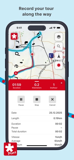
RECORD TOURS ALONG THE WAY

Track your route: You can record your tour automatically in the app (tracking function). This gives you an overview of all important information such as distance, altitude covered and time required.

SHARE AND EXPORT TOURS

Share your experiences: You can share self-drawn tours and recorded tracks with other people via a link. Anyone registered with SwitzerlandMobility Plus can import your tour into their own tour list. You can also export tours as GPX files and transfer them to your GPS device or smartwatch.

HEIGHT PROFILE WITH LIVE LOCATION

Keep track of your tour: On self-drawn tours, you can now see your current location directly in the height profile – marked by a red dot. So you can see right away how far it is to your destination, when you’ll arrive and how many metres of elevation lie ahead.

Find out more about the advantages and additional features of SwitzerlandMobility Plus: https://schweizmobil.ch/en/switzerlandmobility-plus