Dispersed - Free Camping
TravelNavigation

Dispersed - Free Camping

Joseph Casey Kinsey · released 1 Nov 2025 · Open in App Store ↗

Revenue 30d not estimated
Downloads 30d not estimated
Rating 3.74 23 reviews

No in-app products collected for this app.

Rating
United States100%233.74
Canada<1%0

The store shows a different set in every country

Description

BOONDOCKING & OVERLANDING ON US PUBLIC LANDS

Find free camping, dispersed campsites, and developed campgrounds on USFS and BLM land - plus see which roads are

designated for dispersed camping all in one app!

IMPORTANT: This app is independently developed and is NOT affiliated with, endorsed by, or connected to the U.S.

Forest Service, Bureau of Land Management, or National Park Service. Data is derived from publicly available

sources. Always verify current regulations with local ranger districts before camping.

WHY DISPERSED?

36,700+ campgrounds from USFS, BLM, NPS public data and user submitted Hidden Gems (now free for all users)

26,800+ free sites and 15,200+ dispersed sites

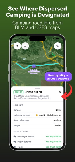
Roads designated for dispersed camping (derived from USFS Motor Vehicle Use Maps, with full US coverage)

Real reviews from other campers

BUILT FOR BOONDOCKING

Find free camping on public land with filters for:

Free vs. paid sites

Dispersed vs. developed campgrounds

Agency type (National Forest, BLM, National Park)

HIDDEN GEMS, NOW FREE

Every community-curated dispersed campsite is unlocked for every user. No subscription required.

TRIP PLANNER

Build multi-stop trips, save them to your account, and route between sites. Perfect for cross-country overlanding and long van life loops. (Premium)

OFFLINE MAPS

Download maps before you lose service. Works in the backcountry where you need it most.

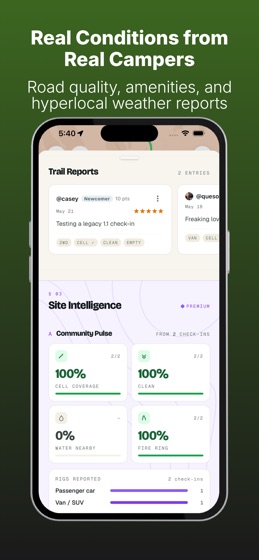
COMMUNITY CHECK-INS

Real conditions from real campers. Check-ins include:

Cell coverage (by carrier)

Vehicle access (2WD, 4WD, high clearance)

Crowding levels

Site conditions

Recent photos

DISPERSED CAMPING ROADS

See which National Forest roads are designated for dispersed camping - data derived from official USFS Motor Vehicle Use Maps (MVUMs). No more guessing where you are allowed to pull off and camp.

SITE INTELLIGENCE

Smarter campsite decisions before you roll out:

7-day weather forecasts and overnight lows

Regulatory monitoring (closures, fire restrictions, alerts)

Condition signals from recent activity

(Premium)

PROFILES & BADGES

Public profiles for contributors. Earn badges for verified Hidden Gem submissions, reviews, and check-ins.

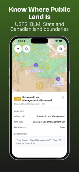
PUBLIC LAND BOUNDARIES

See exactly where USFS and BLM land starts and ends. Satellite imagery included.

PERFECT FOR

Van life & full-time RV travelers

Overlanders & 4x4 adventurers

Boondockers & dry campers

Weekend warriors on a budget

Anyone camping on US public lands

DATA SOURCES

Campsite data derived from publicly available sources:

USFS Recreation Sites: https://data.fs.usda.gov

BLM Recreation Sites: https://gbp-blm-egis.hub.arcgis.com

NPS API: https://www.nps.gov/subjects/developer

Dispersed camping roads derived from USFS Motor Vehicle Use Maps.

DISCLAIMER

This app processes publicly available government data. Road designations and campsite information may change. Always verify current regulations with local ranger districts before camping. You are responsible for following all applicable federal, state, and local laws.

Users agree to the Dispersed Terms of Service which can be found at:

https://dispersedapp.com/terms-of-service/