GPS Area Measure
No in-app products collected for this app.
| Rating | |||
|---|---|---|---|
| United States | 39%16 | 4.75 | |
| China | 29%12 | 4.50 | |
| Saudi Arabia | 10%4 | 5.00 | |
| Taiwan | 5%2 | 4.00 | |
| Germany | 2%1 | 5.00 | |
| Spain | 2%1 | 5.00 | |
| United Kingdom | 2%1 | 5.00 | |
| Guatemala | 2%1 | 5.00 | |
| Hong Kong | 2%1 | 4.00 | |
| Japan | 2%1 | 5.00 | |
| Sweden | 2%1 | 3.00 |
Description
Measure and track land area with professional precision.
GPS Area Measure is a high-performance tool designed for farmers, real estate professionals, and land surveyors to calculate area and perimeter with surgical accuracy using GPS technology.
High-Precision Geospatial Mapping
GPS Area Measure provides surveyors, agriculturalists, and contractors with high-performance GPS tools to calculate perimeter and area with surgical accuracy.
Versatile Mapping Modes:
Dual-Input Precision: Use Crosshair Mode for professional-grade pinpointing or Tap-to-Add for rapid site plotting.
Real-Time Analytics: Access instantaneous area and distance calculations as you define your boundaries.
Dynamic Adjustments: Fine-tune the distance between specific markers to ensure absolute measurement integrity.
Robust Geometry Editor
Refine complex shapes without restarting your project:
Marker Manipulation: Drag and reposition existing points to align with physical boundaries.
Structural Refinement: Add new nodes for irregular land shapes or delete unnecessary markers to simplify your map.
Professional Land Management
Global Overview: Visualize every saved plot and property simultaneously on an integrated master map.
Custom Categorization: Organize saved data into bespoke groups for streamlined workflow management.
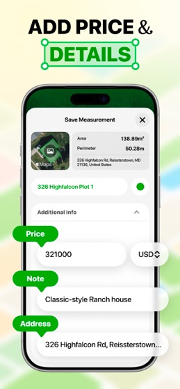
Rich Metadata: Archive measurements with essential details, including addresses, valuation, and field notes.
Technical Versatility
Instant Unit Conversion: Toggle seamlessly between Acres, Hectares, Square Feet, and Meters.
Universal Compatibility: Optimized for diverse industries including Agriculture (field management), Construction (site planning), and Real Estate (parcel verification).