Maptrails
NavigationHealth & Fitness

Maptrails

Pasi Salenius · released 2 Aug 2020 · Open in App Store ↗

Revenue 30d not estimated
Downloads 30d not estimated
Rating 4.83 386 reviews

No in-app products collected for this app.

Rating
Finland87%3364.81
Germany2%85.00
Hungary2%84.88
United States2%75.00
United Kingdom<1%35.00
Sweden<1%35.00
Switzerland<1%25.00
China<1%25.00
Estonia<1%25.00
Poland<1%25.00

The store shows a different set in every country

Description

Maptrails is a modern map browser that packs an amazing experience for hiking, hunting, orienteering, or just enjoying your time outdoors. Only Maptrails offers full featured apps for iPhone, iPad, Apple Watch and Mac.

The app comes preconfigured with a large selection of built-in maps in topographic, nautical, and aerial imagery styles. Save places as map markers that sync between your devices over iCloud. It is easy and fun to measure distances and draw paths on the map, or use Look Around to see street level imagery at any address.

Maptrails Pro one-time purchase unlocks a professional grade feature set. Add your own maps and data layers from standard APIs, and bring in GeoJSON, GPX, IMG, KML or Shapefile data. You can even draw notes directly on the map using touch or pencil!

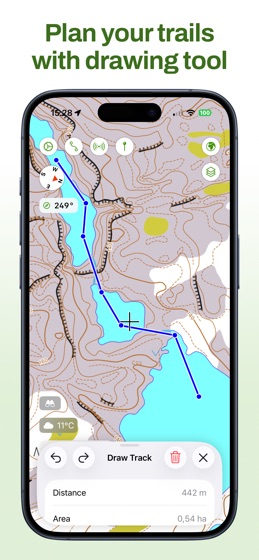
Maptrails makes it easy to plan your upcoming hike by letting you download map tiles for offline use, view up-to-date weather forecasts, or draw tracks on the map and save them to GPX files. During your hike, record the route to a GPX track or workout in Health app, and graph out its speed and altitude data.

For hunters, integration with Oma Riista lets you import hunting areas using area code. Share your current GPS location with a private group of other Maptrails users.

Build your own dog tracker by installing separate Beacon app to another device and pairing it with Maptrails. Its position can then be tracked on the map in Maptrails.

Maptrails Pro one-time purchase unlocks full functionality

Use folders to organize tracks and markers

Attach images to markers from photo library

Track other devices with Beacon app installed

Import hunting areas from Oma Riista service

Get weather forecast for targeted location

Draw notes on map using touch or pencil

Import tile maps from web using browser

Download map areas for offline use

Share your GPS location with groups

Draw tracks on map and save as GPX files

Import GPX files and view them on map

View workout routes from Health app

Record workouts and export to GPX

Add Vector Tile, Tile Map, WMTS and WMS maps

Add GeoJSON, GPX, IMG, KML and Shapefile map layers

Get new features in future versions

If some map available via open data APIs is not yet included, or you want to make your maps available in Maptrails, please email me at [email protected]. Also follow on Instagram at @KartastoApp.

This app has been built by one developer as a hobby project during many evenings and weekends. Please be nice and take this into account when giving feedback.

Icon symbol credit to Wolf Böse (Creative Commons).